Close
Your shopping cart is empty


A drone may need reliable positioning, command and control, video transmission, cloud connectivity, and low-power status reporting at the same time. These functions do not use one interchangeable radio. The system architect must first separate the GNSS positioning path from the data links, then define measurable requirements for each path.

Drone GNSS and wireless connectivity integration (AI application illustration; not an actual product image or performance claim).
GNSS supports position, speed, navigation, return-to-home, mapping, and timing. A magnetometer may add heading information for the flight controller. GNSS, however, does not transmit general telemetry, live video, cloud data, or remote-control commands. Those functions require a separate Wi-Fi, cellular, LPWAN, or dedicated radio link.
A hybrid UAV can therefore use GNSS for positioning, a high-data-rate link for video, and a low-data-rate link for status or backup reporting. The appropriate architecture depends on the mission, coverage, energy budget, airframe space, and target markets.
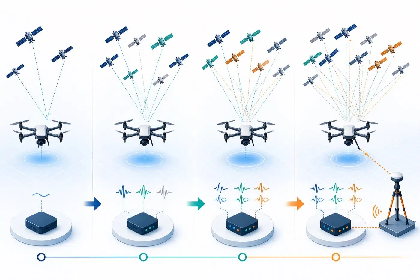
Select GNSS complexity from mission requirements: basic navigation, multi-constellation, dual-band, or RTK (AI technical illustration).
GPS is the United States positioning system. GNSS is the broader term that can include GPS, GLONASS, Galileo, BeiDou, QZSS, and NavIC. More visible satellites may improve availability, but the final result still depends on the receiver, antenna, frequency bands, installation, interference, firmware, and algorithms.
Single-band GNSS is often considered for general navigation and power-sensitive devices. Dual-band reception can help address ionospheric error and multipath effects, but the receiver, antenna, flight controller, firmware, and data format must all support the selected bands.
RTK uses correction data from a base station or network service. A complete RTK solution normally requires a compatible receiver, correction link, base station or network, suitable antennas, and verified integration. Do not treat the word “RTK” alone as a guaranteed accuracy claim.
A drone communication architecture should be planned from mission data flows rather than from a generic range-versus-power chart. Separate the primary command-and-control link, flight telemetry, payload or live-video traffic, nearby configuration, cloud connectivity, and contingency reporting. Each path has different requirements for latency, throughput, coverage, power, antenna placement, redundancy, and regional compliance.
GNSS supplies position and timing data but does not replace a command link. A UAV may use a dedicated RF link for primary control, Wi-Fi or Bluetooth for nearby setup, LTE/5G for cloud or wide-area connectivity where network coverage allows, and LPWAN for low-rate status or recovery reporting. The final architecture must be validated in the intended airframe and operating region.
| UAV requirement | Technology direction | Typical trade-off | Integration focus |
|---|---|---|---|
| Positioning, navigation, return-to-home, timing | GNSS; evaluate multi-constellation, dual-band, or RTK by accuracy needs | Satellite reception; not a general data uplink | Sky view, ground plane, bands, compass interference |
| Primary command and control | Dedicated UAV RF link or an approved cellular architecture | Link integrity and predictable latency take priority over peak throughput | Failsafe behavior, redundancy, interference, antenna diversity, and regional rules |
| Nearby setup, maintenance, or payload configuration | Wi-Fi or Bluetooth | Convenient local access but normally not the sole long-range flight-control path | 2.4/5 GHz coexistence, enclosure loss, access control, and local interference |
| Live video or high-volume data | LTE/5G or a dedicated high-rate link | Higher throughput with network and power requirements | Cellular bands, MIMO antennas, peak current, heat, operator certification |
| Low-rate status, alarms, or tracking | LoRa, Sigfox, NB-IoT, LTE-M, or another LPWAN | Lower data rate, longer range, and lower-power orientation | Regional bands, gateway/network availability, antenna efficiency |
| Positioning plus remote fleet management | GNSS combined with Cellular, Wi-Fi, or LPWAN | Separate positioning, control, video, and status traffic | Antenna count, isolation, coexistence, space, and total power |
Do not select one radio only because it offers the longest nominal range or highest advertised data rate. Start with the mission profile, required control latency, video resolution, flight duration, coverage gaps, recovery behavior, and target countries. Then verify modem bands, network or gateway availability, antenna count, coexistence, peak current, thermal load, and regulatory requirements before design freeze.
| Model | Key Features | Evaluation direction | Items to Confirm Before Integration or Ordering |
|---|---|---|---|
| GP027 | 1575–1610 MHz, RHCP, 25 × 25 × 4 mm antenna body; UAV, vehicle, and handheld applications | Compact GNSS/smart-antenna and customized electrical-interface projects | Official suffix, supply voltage, GNSS/compass composition, receiver model |
| GP030A | GPS/GLONASS/Galileo/BeiDou, u-blox SAM-M10Q, IST8310, UART + I2C, 4–9 V, 20 × 20 × 10.4 mm, 8 g | Compact multi-constellation navigation with heading data | Production firmware, update rate, pinout, configuration retention |
| GP034 | 1561–1602 MHz, RHCP, dual-layer antenna structure; multi-constellation and RTK application wording | Candidate for high-precision, robotics, UGV, and automation evaluation | Full bands, receiver model, RTK architecture, accuracy test conditions |
| GP036 | u-blox DAN-F10N, IST8310, GPS/GLONASS/Galileo/BeiDou/NavIC/QZSS, UART + I2C, 21 × 21 × 15.4 mm | Dual-band GNSS and compass integration for UAV navigation | Supply voltage, complete bands, update rate, flight-controller compatibility |
The appropriate model depends on the required GNSS bands, positioning architecture, compass integration, interface, size, weight, power supply, and flight-controller compatibility.
This table is for preliminary selection and does not replace an official specification, engineering confirmation, or sample testing.
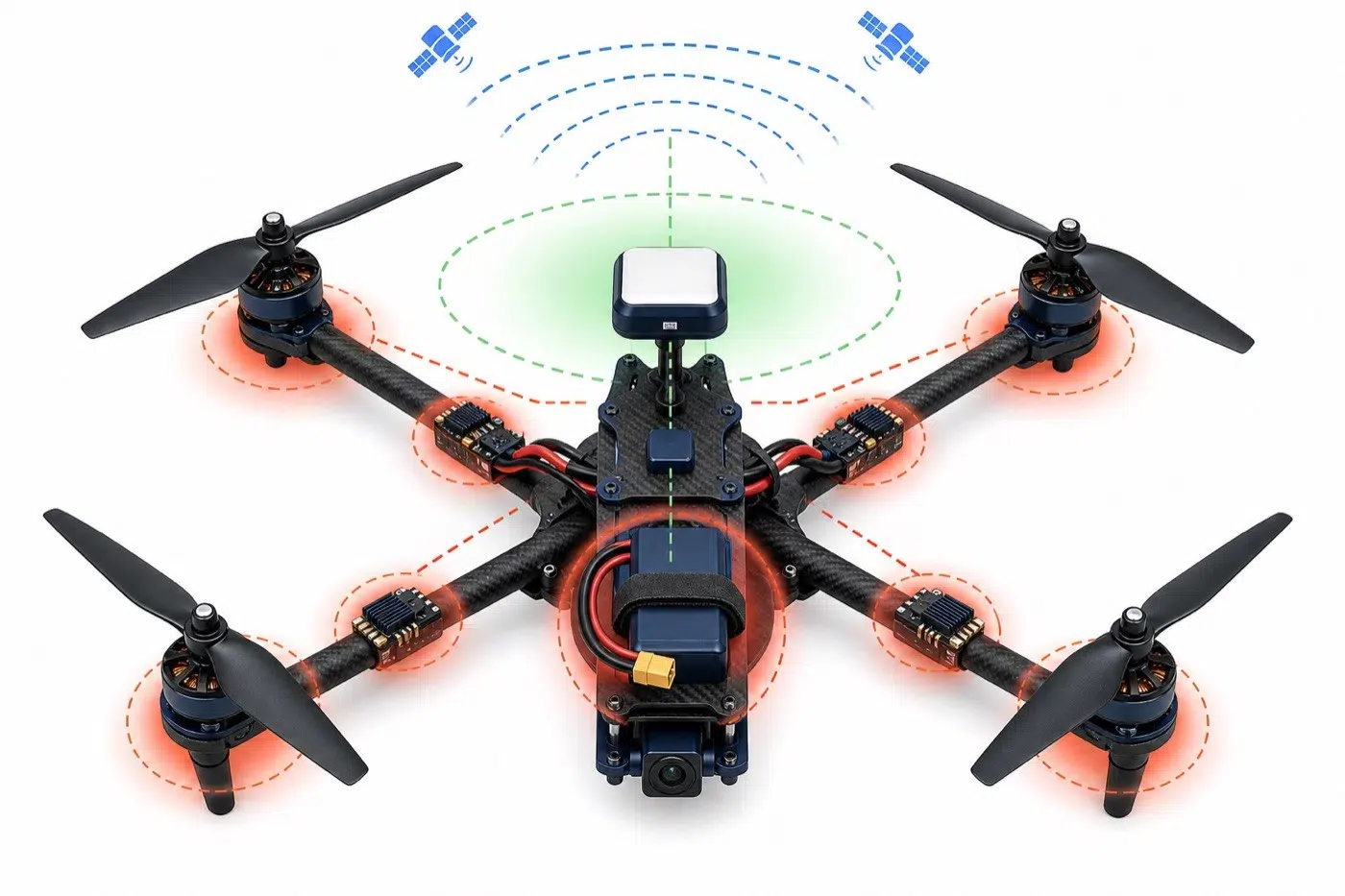
Keep the GNSS antenna exposed to the sky and the electronic compass away from magnetic and high-current interference (AI technical illustration).
No. GNSS supplies positioning, navigation, and timing. LTE/5G, Wi-Fi, and other radios carry general data. Many UAVs need both GNSS and at least one data link.
No. 5G may be evaluated for high data volumes and low latency where coverage and power allow. Wi-Fi, LTE, dedicated links, or LPWAN may be more appropriate for other missions.
Generally no. LPWAN is mainly oriented toward low-rate, long-range, and lower-power status or tracking data. Real-time video normally needs a higher-rate link.
No. Dual-band refers to receiving more than one GNSS frequency band. RTK uses correction data and requires a compatible end-to-end system.
It is not recommended. Motors, ESCs, and high-current wiring can introduce magnetic and electromagnetic interference. Separation and complete-device testing are required.
Successful UAV integration starts by separating GNSS positioning from data communication, then evaluating them together at the antenna, power, mechanical, regulatory, and mission levels. Define measurable requirements before selecting a technology or model, and verify the complete aircraft rather than relying on a component label alone.
Review Evercom's drone module and antenna solutions, explore the GPS/GNSS antenna range and MIMO antenna solutions, or contact Evercom with your flight controller, bands, interfaces, installation space, accuracy, and data-link requirements.